If you're not already familiar with the excellent network of bike routes in and around Edinburgh, these publications will help you on your way.
By Mike Lewis, April 2022. Last updated: March 2026.
If you're planning to do some cycling in or near the Scottish capital, a good map or guidebook will help you find your way around. There are several high-quality cycling maps and guides available for Edinburgh and surrounding districts, in both paper and electronic form. In this article, I'll tell you about those on offer, and help you choose the right one for your needs.
Most Edinburgh-based cyclists would agree: the maps published by Spokes are among the finest cycling maps you'll find anywhere.
These large-scale paper maps show a huge amount of detail. You can see at a glance which bike paths have good surfaces, which roads have a lot of traffic, and which junctions are best to avoid. The maps show bike shops, schools, railway stations, park and ride sites, public parks and gardens, leisure facilities, tourist attractions, and much more. They are printed on recyclable Polyart paper, which is tear- and water-resistant.
As well as Edinburgh itself, Spokes has maps for West Lothian, East Lothian and Midlothian. These cover the areas to the west, east and south of the city respectively. Here is the complete list:
There was also a Spokes map for Glasgow, but this is now out of print.
The Spokes Edinburgh map is at a scale of 1:16,000, which is large enough to show almost every street and bike path in the city. On the back, there is a city centre map at 1:8,000. The other maps are all at 1:30,000, with town centre insets at 1:10,000.
The best place to buy a Spokes map is at a bike shop in the Edinburgh area. Larger bookshops also stock them. Some of the maps are available from Amazon.co.uk, but be warned: these are often out-of-date editions and are more expensive than those sold over the counter. The Edinburgh Bicycle Cooperative is a better option for on-line purchasing. You can also order the maps by post direct from Spokes, with payment by bank transfer or cheque.
Sustrans is the organisation behind the National Cycle Network (NCN). Their Discover series of paper maps shows all NCN routes, as well as main roads, minor roads and certain other bike paths. The quality is high, but at a scale of 1:100,000, they are better suited to overall route planning than to detailed navigation.
For Edinburgh cyclists, the best Discover map is the Round the Forth sheet. It covers part of East Lothian, the northern part of West Lothian, most of Fife, and the Falkirk/Stirling area. The city itself is included, but because of the scale, very little detail is visible.
You can buy Sustrans maps from the organisation's own website, as well as from Amazon.co.uk. You can also find them in larger bike shops, book shops and some tourist information offices.
Sustrans also have an on-line map. This is essentially a Google map (see below) with the NCN routes and a few other bike paths superimposed.
A new cycling map of Edinburgh and south cental Scotland has recently been published under the Cycling Maps UK brand. This is a high quality map, printed on wear-, tear- and UV-resistant paper. One side of the sheet covers Edinburgh, West Lothian, Midlothian, most of East Lothian, the southern part of Fife as well as the Scottish Borders as far south as Peebles. The reverse side takes in an area from Selkirk to Dumfries. The scale is the same as that of the Sustrans Discover series (see above) and with a similar sheet size, but it manages to show more detail than the Sustrans offering, with a more complete coverage of the area.
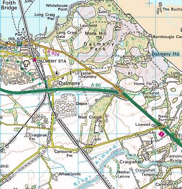
An extract from the OS Landranger map
The Ordnance Survey (OS) is the UK's official mapping agency. It has an excellent reputation for quality, and its topo maps are considered to be among the finest in the world.
The OS Explorer series consists of large-scale sheets (1:25,000) that are especially suitable for walkers and cyclists. These maps show every street, road, country lane, farm track, footpath, cycle path and field boundary – and even individual buildings outside urban areas. They also show a wealth of information of interest to tourists: visitor centres, campsites, picnic spots, public toilets, and much more. Contours are at 5-metre intervals.
The problem with Explorer maps is that you need so many of them. Because of their large scale, each sheet covers a relatively small area. For example, if you were cycling from Edinburgh to Stirling – a reasonable day's outing for a fit cyclist – you would need to carry three separate maps.
For that reason, the OS Landranger Series tends to be more popular with cyclists. These are at a smaller scale (1:50,000), but still show considerable detail. The Edinburgh map (Sheet 66) also covers much of East Lothian and Midlothian, including parts of the Pentland Hills and Moorfoot Hills. Sheets 59, 65, 67 and 73 show the areas to the north, west, east and south respectively.
You can buy Ordnance Survey maps almost anywhere in Scotland: bookshops, cycle and outdoor shops, tourist information centres, etc. They can also be purchased on line, from Amazon.co.uk and the OS's own site.
If even a single OS sheet is more than you want to carry, you have another option: download the Ordnance Survey app from either the Google Play Store (for Android devices) or The App Store (for iPhones and iPads). You will then be able to purchase digital versions of any Explorer or Landranger map, which will be viewable on your mobile device, even without a network connection. Or, to get the best of both worlds, look for a paper version of the map that is flagged as including a "mobile download"; this contains a code which you can use to download the digital map at no extra cost. For more information, see the Ordnance Survey site.
When it comes to on-line maps, Google is, of course, the market leader. Their interactive maps include an option to view cycle routes, but the information is incomplete and not always accurate. Most (not all) of the main bike paths are shown, but access points are not always clearly marked, and the names of the paths are often missing. Some busy main roads are shown as "bike friendly", which clearly they are not. And many very useful bike routes are simply not shown at all.
Google's "Get Directions" feature includes a cycling option, but the results are variable. It sometimes succeeds in showing the best route, but it's just as likely to show ones that are completely inappropriate: routes that follow a busy road, for instance, even when there is a good bike path nearby. We can only hope that this will improve in time.
Cycle Streets on-line map
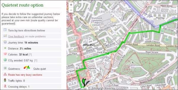
A better option is Cycle Streets. As its name suggests, this interactive tool is a street map designed especially for cyclists. Like Google, you can use it to get cycling directions. Unlike Google, you can choose whether to see a fast route (which might include busy roads), a quiet route (which favours paths and minor roads) or something between the two. Bike paths are shown more clearly than in Google, but the search feature is not as good. A useful extra benefit is the ability to view route profiles, letting you see at a glance how hilly your ride is likely to be.
OpenStreetMap is also worth a look. Its "Get Directions" feature suffers from the same limitations as Google's, but the map itself is much clearer, with cycle paths and other features more clearly shown.
I mentioned the Ordnance Survey app for phones and tablets. But of course that's not the only mapping or navigation app available. A few minutes browsing the Google Play or Apple App stores will find many more, including several that are aimed directly at cyclists.
A good map is all very well if you already know where you want to get to. But what if you are new to the area – or new to cycling – and have no idea where to go for a pleasant ride? The answer is a guidebook.
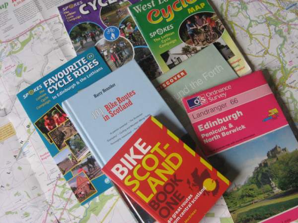
One such book that I am happy to recommend for Edinburgh-based cyclists is Bike Scotland Book One by Fergal MacErlean. It's a slim volume that will take up almost no space in your pannier, but it contains 40 excellent rides of varying standards, all with clear maps and other practical information. It covers the whole of central Scotland, with around half the routes being easily accessible from Edinburgh by rail (trains in Scotland all carry bikes). There are two other titles in the series, covering the Highland and Islands and North East Scotland respectively.
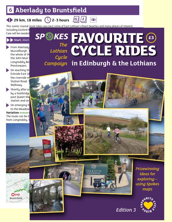
Another useful publication is Favourite Cycle Rides in Edinburgh and the Lothians, from Spokes. This small booklet, which is now in its third edition (published in 2026) describes twelve rides, ranging in length from three to 31 miles. The descriptions are quite brief, so it's best to use the booklet in conjunction with the appropriate Spokes maps. It is available from many of the same sources as the maps (see above).
I can also recommend Harry Henniker's 101 Bikes Routes In Scotland. The routes it describes vary from short outings near towns to long multi-day rides in remote parts of the country.
One other guidebook to consider is Sustrans' Traffic-Free Cycle Rides. This contains details of 150 routes, all based on the National Cycle Network – although not all are as traffic-free as the title suggests. As the book covers the whole of the UK, only a few of its routes will be of interest to cyclists in Edinburgh and the Lothians.
Browse all articles on this site
Cycling Edinburgh is maintained by Mike Lewis.
Contact me
Please contact me with your feedback, suggestions or details of events
you would like me to include on this site. You can email me at:
© Copyright Mike Lewis and contributors.