Edinburgh has a terrific network of cycle paths and off-road routes. But finding your way round them can be tricky. Here's a guide to getting from A to B on two wheels.
By Mike Lewis
First published: April 2013. Last updated: December 2024
The Water of Leith Path
Thanks to its superb network of bike paths, you can reach many parts of Edinburgh on safe, traffic-free routes. But not all the paths are well signposted, and even frequent cyclists don't always know the best route to take.
In this article, I'll give you an overview of the city's core cycle paths. My aim is to introduce you to the principal routes, not to give turn-by-turn directions for every possible journey. If you need help with detailed route-planning, I recommend that you pick up a copy of the excellent Spokes Edinburgh Cycle Map (see here for details).
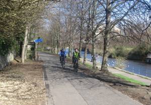
Thanks to the many railway lines that once crossed the area, the north of Edinburgh has the city's highest concentration of off-road bike tracks. For the most part, these paths are well-surfaced, with good lighting and easy gradients. The paths link with each other to form a comprehensive network for cyclists.
Leith to city centre
Start from the Sandport Place bridge at the south end of The Shore. From here, the aptly-named Water of Leith path follows the river for half a mile, then joins the Warriston Path. Just after passing Tesco at Canonmills, you go through the Rodney Street tunnel into King George V Park. You can then pedal up Scotland Street and Dublin Street (steep), across Queen Street (busy, but there's a lights-controlled crossing), and so into St. Andrew Square and the east end of Princes Street (watch out for tram lines). This route is signposted as the National Cycle Network's Route 75 (NCN 75).
West from Leith
The Hawthornvale Path starts from Lindsay Road, near Anchorfield (roughly opposite the ramp leading down to the cruise liner terminal). After passing Trinity Academy and the Bangholm Sports Complex, it reaches Five Ways junction.
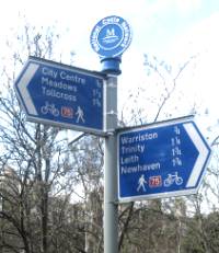
As the name suggests, five paths radiate from this junction. Reading clockwise, they are: the above-mentioned Hawthornvale Path from Lindsay Road; the Chancelot Path, which links up with the Warriston Path (see above); the Goldenacre Path, which also joins the Warriston Path, near the exits for Warriston Crescent and Eildon Street; the Ferry Road path (of which more in a moment); and the Trinity Path, which heads north through a short tunnel to emerge at the Trinity Crescent traffic lights.
If you go straight ahead from the Hawthornvale Path, you will be on the Ferry Road Path, which runs parallel to Ferry Road. After passing the Ainslie Park Leisure Centre, you reach the red bridge just west of Crewe Toll. You can continue straight ahead here to follow the Telford Path to the path junction at Craigleith; or you can turn right for Granton and the Edinburgh Waterfront development (see below).
Roseburn and Blackhall Paths
The Roseburn Path is probably the best-known of the North Edinburgh routes, mainly because it forms part of NCN 1, which links the capital with the north of Scotland. It connects with the Telford Path at Craigleith (see above), from where you can get to the large Sainsbury's supermarket and the Western General Hospital. Heading south, the path passes under Queensferry Road and Ravelston Dykes, to reach Haymarket Yards and Russell Road.
Heading north west from the Craigleith junction, the Blackhall Path carries NCN 1 to Davidson's Mains. Although the path ends just before Tesco's in Cramond Road South, the signposted NCN 1 route continues along quiet residential roads to Barnton, Cramond Brig and beyond.
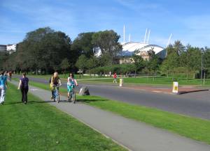
Silverknowes Esplanade
The mouth of the Almond at the west end of the esplanade
Although not part of the official North Edinburgh Network, this route offers excellent cycling. It is a wide, level path, with fine views over the Firth of Forth. The path gets very crowded at times, especially with dog-walkers and children, so be prepared to give way where necessary.
At its western end, the esplanade connects with a footpath that follows the River Almond from Cramond Harbour to Cramond Brig. This is a pleasant path, but, because of two long flights of steps, it's not great for cycling; use the parallel Whitehouse Road instead. At the eastern end of the esplanade, there are several paths to Granton.
Bike paths in and around Granton
The Granton area - and especially the Waterfront development - has its own mini network of cycle paths. The longest of these leaves West Harbour Road opposite the Granton Harbour redevelopment site. This is a well-surfaced path with good lighting and a slight uphill gradient.
The path crosses Saltire Square, passes under West Granton Road, then runs alongside the West Granton Access Road to end just before the red bridge over Ferry Road (see above). From here, you can turn left for Five Ways and Leith, or continue across the bridge to reach the Telford and Roseburn paths and the junction at Craigleith.
A couple of paths link the Silverknowes Esplanade with Granton. From West Shore Road, you can pedal through Waterfront Park to reach Telford College, Scottish Gas and the Morrison's supermarket in Waterfront Broadway. Further east on West Shore Road, a rough track goes past Caroline Park House to emerge in Waterfront Avenue.
Leith to Portobello
From Links Place, a well-surfaced path runs along the northern edge of Leith Links and across a bridge over Seafield Place. It continues to Seafield Cemetery. You can cross Seafield Road here (lights-controlled crossing), and carry on along a narrow shared-use pavement, and then along the Portobello Promenade to Joppa. Or you can loop back from the cemetery through Restalrig and Quarryhole Park to Easter Road. These are all good paths that offer pleasant cycling.
The Innocent Railway Path
This is the longest - and most useful - of the bike tracks in the south east of the city. You can reach it from the St. Leonard's Tunnel, which starts in the East Parkside estate off Holyrood Park Road (near the Royal Commonwealth Pool). Note that this is a long tunnel, and although the lighting has recently been improved, it can be a little claustrophobic. If you prefer to avoid it, you can join the path from a steep driveway just east of the first roundabout at the entrance to Holyrood Park.
The Innocent Railway Path carries NCN 1 to Dalkeith and beyond. It runs gently downhill at first. Within the city, the path gives access to Jewel Park, Bingham and Brunstane railway station (on the Borders Railway). It crosses two main roads - Duddingston Road West and Duddingston Park South - with lights-controlled crossings in both cases.
From Brunstane station, you can continue on the signposted NCN 1 route along residential roads and short sections of path towards Musselburgh railway station (on the Edinburgh to North Berwick line) and Monktonhall. Or you can take a rough, narrow path alongside the Brunstane Burn to join the busy Edinburgh Road just west or Fisherrow Harbour.
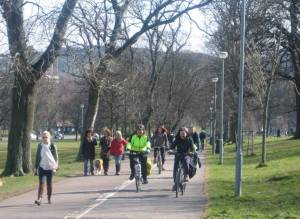
Cycling in Holyrood Park
The shared-use path in Holyrood Park
There are no official off-road bike paths in Holyrood Park, but there is a useful shared-use path that runs alongside part of the main Queen's Drive. It's not particularly wide, and has no lighting, but the surface is good.
It starts at the second roundabout after the Holyrood Park Road entrance (near the Commonwealth Pool, the Pollock Halls and the start of the Innocent Railway). The path follows the road round to the west and north, passing Dynamic Earth, the Scottish Parliament and the Palace of Holyrood House. It ends by St. Margaret's Loch, near Duke's Walk.
The roads in the park are closed to motor traffic during the day on weekends - usually until late afternoon. At the time of writing, the upper part of Queens' Drive - the steep one-way section that climbs to the back of Arthur's Seat - is also closed on Mondays and Fridays, but that might change.
The Union Canal towpath
The path that runs alongside the Union Canal is the most useful of the paths in the south west of the capital. It is reasonably straight, completely level, and entirely free of traffic. But parts of it are narrow, and it tends to be crowded with children, dog-walkers, joggers and anglers, so don't expect to get up any speed. There is no lighting on the path.
The path starts at the Lochrin Basin in Fountainbridge. It provides access to Viewforth (via a short flight of steps), Boroughmuir High School, Harrison Park, Boroughmuir RFC and Meggetland. After crossing the Slateford Aqueduct (to be avoided by those with a poor head for heights), it goes past Wester Hailes and Hermiston, then proceeds to Ratho and beyond. The path is designated as NCN 754, and also carries NCN 75 for the first couple of miles.
The Water of Leith Walkway
It's just about possible to cycle alongside the Water of Leith for the entire 12 miles of its length between Leith and Balerno - albeit with a few sections on roads, and a few more on paths that are better suited to two legs than two wheels.
The part of the route that's best for cycling starts at the Roseburn Place entrance to Roseburn Park. It follows the river past Murrayfield Ice Rink and the rugby stadium, then crosses Balgreen Road and Gorgie Road (both with lights-controlled crossings). This section of the path ends at the Water of Leith Visitor Centre in Lanark Road.
The next stretch is steep and narrow, and difficult to navigate in parts. Cyclists often prefer to turn right instead, and pedal along Lanark Road, regaining the path via the footbridge just beyond Redhall Bank Road. The same bridge also provides a link between the Water of Leith Walkway and the Union Canal towpath (see above).
The remaining stretch of the Walkway offers much easier cycling as it heads out to Colinton, Juniper Green, Curry and Balerno.
By now, you have probably realised that the local bike network extends its reach to just about every part of the capital. But there is one important exception. There is a definite a gap in the network in the centre of the city. However, in March 2024, the City Centre West to East Link (CCWEL) was finally opened (after nearly ten years of design and consultation), going a long way to bridge that gap.
CCWEL
The CCWEL starts at Roseburn Terrace, close to the Murrayfield rugby stadium and ice rink. Here it links with the Water of Leith Walkway and the Roseburn Path. The route runs eastward alongside West Coates and Haymarket Terrace, then continues through the West End, past St Mary's Episcopal Cathedral, round Charlotte Square and into George Street. It then skirts St. Andrew Square (for the National Portrait Gallery and the bus station) before ending in Picardy Place, from where it links with Leith Walk. For much of its length, it is segregated from road traffic, the main exception being George Street. A long-term plan exists to remove most motor traffic from George Street, but until then you will be cycling among cars and taxis. There is also a difficult road crossing at North Charlotte Street, where care is needed. Despite these gaps, the CCWEL provides a mostly safe west-east route through the city centre.
The Meadows
The Meadows and Bruntsfield Links offer easy cycling near the city centre.
Another west-east route - albeit not exactly in the city centre - is North Meadow Walk. This runs along the northern edge of the Meadows, from the Tolcross end of Melville Drive to Hope Park Crescent, which is near Summerhall and the Queen's Hall. It's a wide, level path with good lighting.
Half-way along its length, North Meadow Walk crosses the north-south Middle Meadow Walk. This popular shared-use path runs from Lauriston Place to Marchmont and Sciennes, passing the Quatermile development and the university buildings around George Square. At Melville Drive, it connects with Leamington Walk, which heads west (uphill) over Bruntsfield Links. It in turn connects with Leamington Terrace, which heads downhill to meet the Union Canal towpath by Lower Gilmore Place.
West End to Lothian Road and Fountainbridge
For a possible north-south route across the centre, head to the south west corner of Rutland Square. Take the ramped path from in front of the Norwegian consulate, through Rutland Court and over the footbridge across the West Approach Road. Turn left into Festival Square for the Sheraton Hotel, Lothian Road and the Usher Hall.
Alternatively, turn right after the footbridge to reach the Edinburgh International Conference Centre (EICC). From the other side of Morrison Street, another path links up with Port Hamilton and the start of the canal towpath at the Lochrin Basin.
Roseburn to Union Canal
An entirely new north-south route - just to the west of the city centre - was opened at the end of 2024. Despite its name, the Roseburn to Union Canal route doesn't quite join the canal (it starts some 300 metres to the north west), but nevertheless provides a very useful traffic-free link from the Fountainbridge area to Roseburn, from where you can reach the Roseburn Path, the Water of Leith Walkway and the CCWEL. You can access the route from the Telfer Subway (next to the Fountain Park entertainment complex), Dalry Road (next to Lidl), Duff Street or Russell Road. The entire route is well lit and well surfaced, and provides a welcome addition to Edinburgh's cycling infrastructure.
The Scottish capital clearly has a superb network of bike paths. In this article, I've described the core routes - the main arteries that will get you from one part of town to another. (If you're interested in routes out of the city to the surrounding countryside, see my article, Escape Edinburgh by Bike.)
But that's not all. There are also scores of shorter bike paths, shared-use pavements, off-road tracks, link-ups and cut-throughs - far too many to mention here. If you really want to get to know Edinburgh as a cyclist, pick up a copy of the Spokes map, get the bike out, and start exploring.
Browse all articles on this site
Contact me
Cycling Edinburgh is maintained by Mike Lewis.
Please contact me with your feedback, suggestions or details of events
you would like me to include on this site. You can email me at:
© Copyright Mike Lewis and contributors.